Thursday, September 13, 2018

Bartonville, IL: Largest Feed Mill in 1920: Allied Mills

(3D Satellite)

Michael Broshears posted
June 1988 Allied Mills.
David Jordan: This plant closed in November that year.

Robert Learmont posted three photos with the comment:
Bartonville, IL. 9-11-2018. A quick search shows this as formerly being “Allied Mills” - the largest feed mill in the world when it was built in 1920. The whole complex looks abandoned, but someone keeps the lights on in the elevator at night. Real creepy place to drive by at dusk. The tall building towers directly over the north side of US 24.

1

2

3

Dennis DeBruler commented on Robert's post
I saved the 3D satellite image because it still shows the smokestack.

1 of 9 photos in the area posted by Josh Clark
Last weekend, I had the opportunity to document another great run of the KJRY’s Mapleton turn job. They ran with a healthy 5 units, including three classic GP20s in the middle.

Kathy Maple posted, cropped
Harry Wahl The old Purina dog food factory.

Rick Engelbrecht posted

Roger Holmes posted
KJ en route to the TZ this last Thursday to make a delivery and pick up.
Jackson Vandeventer posted
Today’s chase of the F’s final run into Peoria.
[Eastbound]

Jackson Vandeventer posted
Today’s chase of the F’s final run into Peoria.
[Westbound]

Roger Kujawa posted
Last Run of the Keokuk Junction F units into Peoria 8-6-19. At Allied Mills near Bartonville on the way to deliver cars to the TZPR.

Matt Smith posted three photos with the comment:
Allied Mills, Inc. Peoria County.
On my to-do list forever. The peaked roof gives it the look of ancient temples I toured in Greece. I've been passing it by for 26 years, but of late I've noticed the ominous presence of the wrecking crane there in front. Abatement notices on the fence suggest it might not have long to go. So today I got up with the sun and snapped this. (Because people seem interested I've now added two more familiar views, approaching from the north and the south.)

1
Jane Perry Nissen I drive by there about once a month. Unless there’s been some new development, that crane has been there for quite a while. I always intended to get a picture of the chimney that said Allied Miles and then one day it was gone.
James Randell The crane has been there for years...I’m sure being as how this building sits literally feet from the highway plays a part in the delay.

2

3


1939 Aerial Photo from ILAP
I got this photo to confirm that rail access was on the south side.
Roger Kujawa posted
Robert Massey: A former WW2 era US Army 65 Ton center cab, from Whitcomb. @ 650 HP.

Tipton, IN: Surprised by a NKP diesel and Indiana Transportation Museum

(Satellite)

We were heading westbound on IN-28 through Tipton, IN, when my wife said look. Fortunately, I looked in time to safely pull into a parking lot. This is what we saw just south of IN-28.

20140830 0073c

Since I was born and raised in Fort Wayne, IN, I knew that NKP's mainline ran through Fort Wayne. I didn't know that NKP was this far south. When I got home and did some research, I learned that Tipton was at the intersection of the east/west route and one of the north/south routes of the Lake Erie & Western, which was bought by NKP. According to a 2013 NS system map, the east/west route is still operated by NS. The route north of Tipton is owned by NS, but it is out of service.
DeBruler

As I got out of the van, the train started south. So I hurried up and grabbed some shots as it left.


Digital Zoom of the above photo
Since NS did not own the track going south, further research indicated that I caught an exhibition train from Noblesville, IN, of the Indiana Transportation Museum. That was back in 2014 before there was even a hint that Noblesville would kick the museum out of town. Look at how fresh the ballast is on that track. It is a shame that money was spent on track maintenance just a couple of years before the local governments started the process of kicking ITM off those tracks so that they could have a trail.

Update:
Ben Planck posted
LE&W Tipton Yard and division point ca 1920
David L White Ben, what's the big building to the south of the main toward the west end? [So we are looking West.]
Ben Planck David L White Looking for a sanborn valuation for a clue tonight.
George Greene David L White That should be the ice house. Reefers were iced in Tipton until the new change point was changed in the 40s.
Ben Planck Nope, to far out of town for Sanborn.

George Greene I always wondered why the LE&W did not build the engine facility at the west end of yard where there is more room and no Buck Creek to bridge with the engine lead.
David L White One would suspect it had everything to do with being closer to town and within a easy walking distance of most of their workforce.
George Greene Most probably. I knew at least one engineer working on Chessie in Kentucky who never learned to drive. He walked to work most days.
Ben Planck Tipton had three streets (Green, Kentucky, Columbia) near the east end of the yard. This is were most of the workers lived.

Ben Planck commented on his post
Cousin George is right, says ice house on this track diagram

This photo wsa moved to "Tipton, IN: NS/NKP/LE&W Depot and Railyard."


Tuesday, September 4, 2018

Mill Shoals, IL: Classic Concrete Silo Elevator

(Satellite)

On a trip back to Chicagoland, I skipped my usual I-57 route so that I could take the ferry across the Ohio River for IL-1. This got me on a stretch of US-45 that I had never taken before. As I passed through Mills Shoals, I happen to spot a grain elevator about a block to the left. I had recently read Chapter 2 of Jeff Wilson's The Model Railroader's Guide to Grain and recognized this elevator as a text-book example of an early collection grain elevator. Since it was still in great shape, I dove over to it, parked the car, and walked around it to get photos on all sides. The covered truck dump/load facility is a nice feature for a rather small elevator.

20170322  8197rc, West Side
North Side
I did not crop this photo to demonstrate how I try to avoid the "keystone affect" when taking photos of tall structures. Since my camera has much more resolution than can be displayed on a computer screen (let alone a smartphone), I use a wide angle lens and frame it with the structure in the upper half and then crop out the foreground. Notice the two spouts to load freight cars that have not been here for a long time.

East Side
South Side
The spouts that used to load freight cars on the B&O railroad that used to run through town are still intact.

I went over close to the old right-of-way and shot the view to the north. Notice that they have added three steel bins to increase their capacity.

Then I turned around and took a photo looking south. The B&O route through this town was bought by Prairie Trunk Railway. PARY abandoned the line in 1985. It is rather amazing how long creosoted timbers can last.

(Facebooked)


Sunday, September 2, 2018

Disko, IN: Erie's grade seperation

(Satellite)
Mark Llanuza posted
Its March 1976 only a few weeks left of operations of the Erie Lackawanna railroad [photographer Don Ellison ] captured this westbound at Disko Ind .I went back in April 2017 41 years later to match everything back up again at same location.
Ken Morrison Both Erie mains. The second was added at a later date, and was totally re-engineered as opposed to just mimicking track 1.Leo G. Clay A very similar track situation is on State Line road between Ohio and Indiana, just west of Hicksville, Ohio. Still in operation, today.Alan Culley Same over on SR 15 between Wabash and Silver Lake. The underpass was very narrow and saw a lot of crashes. The different levels can be seen off the highway.Dennis DeBruler One advantage of two different embankments is that it makes a wide "land scar" and thus easy to find on a satellite image, https://www.google.com/.../@40.9844143,-85.../data=!3m1!1e3

Saturday, September 1, 2018

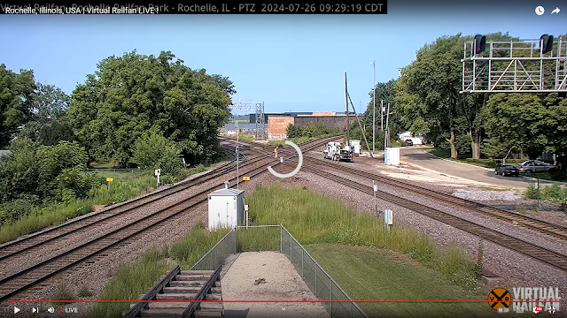
Rochelle, IL: NX Crossing: BNSF/CB&Q vs UP/C&NW

(Satellite)

You see a lot of photos of this crossing because it is a popular railfan spot. But this is the first time I have seen the tower. Note the signalling pipelines making a turn at the crossing to follow the CB&Q tracks to the left. I took photos of the rail park itself. My own railfan photos from the rail park are in a separate posting.

Steve OConnor posted
Rochelle diamond from 1956. Embree collection.

Andy Zukowski posted
Chicago and Northwestern, Rochelle, Illinois 1956
Dave Rodgers: The industrial lead track off the C.B.&Q to Del Monte isn’t there. Must have been before Del Monte was built. Love this pic! Always wondered where the tower was located.
Mike Schattl: Dave Rodgers The original tower was located on the west side of the diamonds. It must've been demolished by a derailment because they built a newer tower on the east side of the diamonds which was also destroyed by a freight derailment.
Steve Schafer: Anyone know what year the tower was removed? Also, whose employees ran it - CBQ or CNW?
John Richmond: Steve Schafer, it was a CNW tower. Think I have seen a photo of it as late as 1965, but no later than that.
Richard Rasmussen: It was served by CB&Q, CNW and MILW. MILW had trackage rights on the Q.
Nick Gawriluk: Those diamonds are being worked on around the clock. It’s almost down to a science how pieces are interchangeable.
Dave Bahnsen: https://youtu.be/Sinc7_oAUlA [live cam]

John Frey commented on Andy's post
2022 8.25 same location the building in background is still there but now it is owned by the US GOVERMENT

Kenn Krizanitz added two photos as comments on John's comment.
1

2

Sure enough, when I fired up the live cam to check it out. MoW was working on the diamonds.
Live video

Jim Arvites posted
Aerial view looking east of the Chicago, Burlington & Quincy Railroad and the Chicago & North Western Railway crossing at Rochelle, Illinois circa 1920's. The CB&Q crossed from the lower left to upper right of picture and the C&NW from lower right to upper left. Note the Tower and future site of the Rochelle Railroad Park in center of picture.
Jim Arvites posted
View of the Chicago & North Western and Chicago Burlington & Quincy diamonds at Rochelle Tower in Rochelle, Illinois circa 1920's.
Alan Fricker: The railroad park is now opposite the tower. I like this shot, I know where the tower was. Thanks.

I was taking photos of the signal bridges because they were in transition between the old and the new. The new is needed for Positive Train Control. This one has a "(UP) NX XING" sign that shows UP operates the crossing.

20150916 4732, cropped-25+15
I wonder what caused the blue line.
Another signal bridge being replaced.
Note the reefers on the siding on the right of the initial B&W photo. They are probably headed to the old Del Monte plant.

Steve OConnor commented on his posting
1949
201509
The only thing food related that I could find was the Del Monte Credit Union and a water tower still labeled Kraft.
Chris Roberts posted
Burlington Junction Railway, BJRY, 8701 an MLW S13 switching the Del Monte Foods plant in Rochelle, IL on 1/6/2020.
[Given Robert's date, the plant must still be in operation. Nope. It is probably this new plant.]

Steven J. Brown shared
Who says there are no surprises trackside anymore?? I do. I whine about it all the time to anyone that will listen. (See here sonny, back in my day.......).
I am also know to be wrong sometimes.
We are in Rochelle, Illinois on September 22, 2020. I am west of the BN/CNW crossing (Well BNSF/UP crossing - I am in denial). I'm waiting for a westbound on the BNSF when I hear a burbling sound. I look over and see the top of a switcher working a nearby industry. Now I hear Scooby-do's voice in my head, "huh?" That kinda looks like an Alco? Then it powers up and a cloud of smoke rises. Now I assume I'm hallucinating!
Burlington Junction Railway 8701 is a MLW (Alco) S13 built in 1959 as Canadian National 8607. It lives and works in the Rochelle Industrial Park.
Thanks for the surprise, maybe the poor switcher deserves a coat of paint! (BTW, I missed the BNSF freight.)

Daniel Metzger commented on Steven's post
I shot this one there yesterday. Looks to be a similar unit.

Bill Wagner posted three photos with the comment: "Riding the Kate Shelley 400 was the preferred way of getting from Dixon to Rochelle IL, but sometimes accidents happened.  By the time this wreck occurred in 1965, one of my high school classmates (probably fellow website contributor Craig Willett) had gotten his driver's license.  Transportation problem solved.   (Captions with Photos.)"
Mike Holmes: Their watching the temporary track very closely
1
1. The eastbound Morning Zephyr was the first train to pass through the wreckage of a North Western freight that had fouled the diamonds. Miraculously enough, the Rochelle tower (hidden by the lead E-9) was spared. (Presumably the towerman's trousers were not.)

2
 If you look closely, you can see several small children gazing at the North Western wrecker from their coach seats in Silver Brook. Today's Rochelle Railroad Park is located just a few feet away (to the lower left of the photo). https://www.rochellerailroadpark.org/webcam.php

3
The clean-up crew had plenty of time to rest as the westbound Morning Zephyr (shown here), North Coast Limited, and Empire Builder picked their way through the wreckage an hour or so later. It would be several more days until the North Western's tracks were once again open for business through Rochelle.