Sunday, May 28, 2023

Sykesville, MD: Restaurant/B&O Depot

(Satellite)

Street View, Oct 2022

Marty Bernard posted
B&O Station Sykesville, MD with flood damage, (tropical storm Agnes) Patapsco River, June 25, 1972. Bill Howes photo
Jeff Branch: There's an old Life-Like kit of this station in HO scale.
Allen Garbey shared
Anne Thomas: It's a restaurant now; I ate there a few years ago; the food was wonderful.
Richard Palmer: That [Anges] was a bad one. it even uncovered the old roadbed of the first rail of the old mainline. There was a rainstorm thru the Patapsco valley from Frederick down which changed everything in 1868, 21 inches of rain in an hour which did a lot more damage than any hurricane that hit Maryland since the Europeans first came her in mid 1500's, before the English there were spanish explorers and then came French trappers years before the English settled here in a Catholic lrish colony of Lord Baltimore.
Marty Bernard posted
9. B&O Sykesville Station, MD, flood damage, note missing highway bridge on right, June 25, 1972. Bill Howes photo

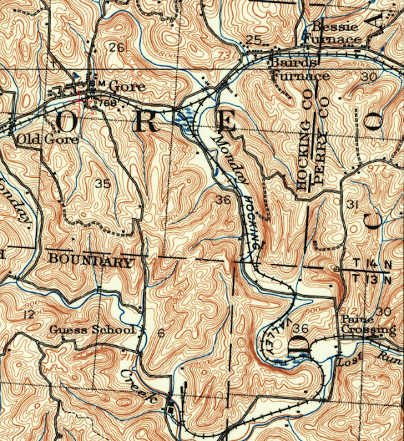
Gore, OH: 1876 Coal-Fired Iron Ore Furnace

(Satellite)

Hocking Valley Railroad became part of the C&O.

Mark Howell posted
A ca. 1887 photo of the Gore Furnace at Gore, Ohio in Hocking Co. This coal-fired furnace, built in 1876, was one of the largest of the Hocking Valley iron furnaces.
William Thomas: Part of Hanging Rock iron ore area?
Mark Howell: William Thomas , no that would be closer to the Ohio River in Lawrence and southern Jackson Co. This was one of five iron furnaces in Perry Co. including Bessie Furnace, Gore, Moxahala, Baird's, and Orbistan.
Jashua Ames shared

Jason Zimmerman commented on Mark's post

1907 Logan Quad @ 62,500

Saturday, May 27, 2023

Alameda Naval Air Station could also dock ships

(Satellite)

Today the USS Hornet - Sea, Air and Space Museum (29,052 photos) is docked there.

I knew the Navy used to be able to dock ships in Pier 70 and Hunters Point. Now I learned that the Navy could also dock big ships on the east side of the bay.

The Warshipologist posted
USS Coral Sea (CVA-43), with A-4E Skyhawks from VA-153 "Blue Tail Flies" and VA-155 "Silver Foxes," moored to pier #3 South, U.S. Naval Air Station, Alameda, California, 22–26 July 1967. USS Hancock (CVA-19) is moored to pier #3 North, and USS Ranger to pier #2 North. Other ships present include: USS Bellatrix (AF-62) and USS Aludra (AF-55), moored port side and starboard side, respectively, to pier #2 South; and probably USNS Breton (T-AKV 42), astern of Coral Sea.
Photo and caption from Navsource (William T. Larkins)

The Warshipologist posted
USS Carl Vinson (CVN-70) & USS Abraham Lincoln (CVN-72) moored at NAS Alameda in March 1994. CVN-72 undergoing a post-deployment dockside refit.
RD Dan Narayan: Alameda...the past home of "The Ageless Warrior " USS CORAL SEA CV-43. My favorite ship!! Both now gone.
[Some comments indicate the NAS closed in 1997.]

The Warshipologist posted
Aerial starboard view of the nuclear-powered aircraft carrier USS ENTERPRISE (CVN-65) moored at Naval Air Station, Alameda on September 15, 1983.
National Archives
James Stammers: “Excuse me, sir! Can you direct us to the naval base in Alameda? It's where they keep the nuclear wessels.”
[Chekov in the Star Trek movie about time travelling and the whales.]

The Warshipologist posted
The Nimitz Class Aircraft Carrier USS CARL VINSON (CVN 70), (center) joins the USS ENTERPRISE (CVN 65) (left) and an unidentified Nimitz Class aircraft carrier (right) undergoing refurbishment at the Alameda. Next to the unidentified carrier is an unidentified Virginia Class Guided Missile Cruiser docked bow to bow with the USN Kilauea Class Ammunition ship USS SHASTA (AE 33)
National Archives
 
Military Technology posted
USS Enterprise (CVN-65), USS Ranger (CV-61) and USS Oriskany (CV-34)  tied up at Alameda circa 1970s. Also present are the cruisers USS Bainbridge (CGN-25) and USS Truxtun (CGN-35).
Thanks to Chuck Walden for identifying the cruisers.
1967-1976 timescale.

The Warshipologist posted
Four aircraft carriers berthed at Alameda in June 1960. Top left is the Bogue class escort carrier USNS Breton (T-AKV-42) loading various types of planes for transportation. 
Astern of Breton is Essex class carrier USS Hancock (CVA-19), about to embark on her WestPac cruise. 
Below the Hancock is the USS Coral Sea (CVA-43).; She has just completed her SCB-110 refit at Bremerton, WA, and is working up her air group before deployment.
At the bottom of the picture is USS Bonhomme Richard (CVA-31). She has just completed a WestPac deployment and is about to head to Bremerton for an overhaul. You can see the cars on the flight deck, a sign of a change of home base.

Research Library, USS Midway Museum posted
14 September 1943, 80 years ago today: The Essex-class aircraft carrier #USSYorktown (CV-10) loads aircraft, vehicles and supplies at Naval Air Station Alameda, California. Three Lockheed PV-1 Harpoons are parked on the flight deck. She left the next day for Pearl Harbor.
National Naval Aviation Museum photo # 1996.488.243.041

MilitaryPhotoDepot posted
(7/30/1995) High oblique aerial view of the Naval Air Station Alameda, looking west (vertical format), showing the airfield and aircraft carrier pier complex hosting Pacific based surface forces. The aircraft carrier USS Kitty Hawk (CV-63) is tied up to the left. The former Essex class anti-submarine carrier Hornet (CVS-12) is moored to the right. The Hornet has been deleted from the naval register and will soon be scrapped USN Image/ PH2 Bruce Trombecky

I wish I could find a photo that shows how they loaded the airplanes onto a carrier.
The Warshipologist posted two photos with the comment: "USS Bataan (CVL-29) departing San Francisco on October 7, 1944. She is transporting VP-128 from NAS Alameda to Pearl Harbor and is being photographed by a navy blimp. Lockheed PV-1 Venturas onboard."
1

2

The Defense Post posted
United States Navy aircraft carriers representing four separate classes docked at the Naval Air Station Alameda in September of 1945. The ships are (front to back):
USS Saratoga (CV-3)
USS Enterprise (CV-6)
USS Hornet (CV-12)
USS San Jacinto (CVL-30)
The photo is interesting because it helps highlight the difference in size from between the carriers.
Saratoga was a Lexington class carrier that entered service in 1927. She was 888' in length and displaced over 43,000 tons at full load. By this time, she was carrying 70 aircraft.
Enterprise was one of the Yorktown class carriers and entered service in 1938. She was 809' overall and displaced a little over 32,000 tons when fully loaded. At the time, she would carry between 70 and 80 aircraft.
*A good example of the benefits of a purpose built carrier. The smaller Yorktown class could carry the same number of aircraft and more aviation fuel compared to the larger Lexington class that were converted from battlecruisers!*
Hornet was one of the Essex class carriers and entered service in 1943. She was 872' overall and displaced just under 36,500 tons at full load. At the time, she was carrying 90 aircraft.
Lastly we have San Jacinto, one of the Independence class light carriers that entered service in 1943. She was 622' in length and displaced over 14,000 tons at full load. At the time, she carried 33 aircraft.
Ranked: The US Navy’s 5 Best Aircraft Carriers Ever
Marlene Van: USS Hornet, today, is tied up at the very same pier as it was in this photo. An excellent museum ship, she is not to be missed.
John Clampitt: San Jacinto is the carrier, George Bush Sr flew off of in WWII.
Michael Koshel: At the end of the war, the Saratoga and the Enterprise were the last two surviving aircraft carriers that comprised “The First Team.” The Lexington was lost at the Coral Sea, the Yorktown was lost at Midway, the Hornet and Wasp were lost in the campaign for Guadalcanal.


Laurel, MD: 1884 MARC/B&O Depot

(3D Satellite)

Three of 9 photos posted by Marty Benard with the comment: "These are scans of the slides of the late Bill Howes.  He was a very interesting railroader.  If you didn't know Bill, you my want to look at this from TRAINS:  https://www.trains.com/trn/news-reviews/.../william-f-howes-jr.../
a
B&O Laurel, MD Passenger Station looking north on February 20, 1972, Bill Howes photo. Used also as track supervisor's office.

b
B&O Laurel, MD Passenger Station looking north on February 20, 1972, Bill Howes photo. Used also as track supervisor's office.

c
B&O Laurel, MD Passenger Station looking south on February 20, 1972, Bill Howes photo. Used also as track supervisor's office.
Arthur House: The photo also shows the Laurel freight house, which was destroyed by fire not long after Bill’s photo.

Pamele Moskie posted
Baltimore & Ohio Railroad station, Laurel, Maryland
Pamele Moskie shared
 
Laurel Historical Society posted
Today marks the 190th anniversary of the opening of the B&O Railroad Washington Branch, which connected Baltimore, MD to Washington, D.C. Did you know the Laurel Station is the last of the old Washington Branch stations? Join us this Thursday, August 28th for a free webinar on the Washington Branch and its rich history, presented by Conor Conneally, Museum Manager of the @B&O Ellicott City Station Museum. For more information, please visit our event page. http://bit.ly/4oyFhTi
Thomas Dunne shared

Laurel was still a small village in the 1950s.
1951 Laurel Quad @ 24,000

Street View, Jul 2019
Note that the abutments for the overpass is cut stone and it allows just one lane of traffic with a low clearance.

The plaque in the above view reads:
LAUREL RAILROAD DEPOT
BUILT BY THE BALTIMORE AND OHIO RAILROAD IN 1884 [1864?], THIS "AMERICAN QUEEN ANNE" STRUCTURE CONTINUES IN DAILY USE. THE ARCHITECT FRANCIS M. BALDWIN ALSO DESIGNED THE REAR WING OF THE STATE HOUSE IN ANNAPOLIS.
tHE BUILDING WAS PLACED ON THE NATIONAL REGISTER OF HISTORIC PLACES IN 1972.

Dale V Rockwell commented on an Ellicott City depot photo: "E. Francis Baldwin was the B&O's Head Architect from 1872 until early 1900s. He designed most of what B&O built during that time period. His work is distinctive and stylish." This argues for a date of 1884 instead of 1864 on the plaque.

Margty Bernard posted two photos with the comment: "B&O Laurel, MD Station Recently Painted Green, November 1981."
1. B&O Laurel, MD station recently painted green which was said to be the early color of the station (looking north) Bill Howes photo, November 1981.

2. And the next slide Bill took. B&O GP40-2 4257 with a westbound freight at the Laurel, MD, Bill Howes photo, November 1981.

Friday, May 26, 2023

Sherwood, OH: (WO) Tower: B&O vs. Big Four and B&O Depot

(Satellite, the north/south Big Four route is gone.)

Darren Reynolds posted
B&Os station and (Big) tower at Sherwood, Ohio
No date
Chad Winans: Were Sherwood and Walkerton the only three-story B&O towers between Willard and Chicago?
Darren Reynolds posted
B&Os "WO" tower & station Sherwood, Ohio 
Photo & Date: Unknown

I'm surprised that there is not a rectangle in the northwest quadrant of the crossing to represent the depot. I would expect that it was still being used in 1960.
1960 Sherwood Quad @ 24,000

The grain elevator was along the Big Four route. It is now a feed mill.
Street View, Aug 2022


Thursday, May 25, 2023

Cleveland, OH: 1856 Waterworks

(Satellite)

In the background of some photos of the Shipyard in Cleveland, I noticed some buildings with red roofs. They are one of the four pump and water treatment facilities for the Cleveland water supply.

ClevelandWater_first
The waterworks designed by Theodore Scowden started operation on Sep 24, 1856. " The original pump station is now the site of the Garrett A. Morgan Water Treatment Plant (one of four in Cleveland Water’s system) which pumps an average of 60 million gallons of water a day." The water intake was located 300' out into Lake Erie and just west of the mouth of the Cuyahoga River.

Pumps via ClevelandWater_first
The two Cornish engines were the first west of the Allegheny mountains.

Reservoir via ClevelandWater_first
The reservoir held 6 million gallons of water. This green space was the site of the reservoir.

Promenade via ClevelandWater_first
The reservoir "was the highest man-made structure in the city at the time."

As Chicago discovered, when you dump your waste into the lake, the lake becomes polluted; and people get waterborne diseases. So in 1869 they started a 5-year project to dig a 6,600' water intake tunnel. In 1911 they added "chlorine to its water to help eradicate cholera and typhoid fever." After several more pump stations and reservoirs were built, they built their first treatment facility in 1917.   [ClevelandWater_history] (This source says that the 1896 tunnel was four miles long with a 9' diameter. But I believe it is wrong. It was the 1916 tunnel that was four miles long.)

ClevelandWater_history
By 1975, their entire service area was getting filtered water.

ClevelandWater_history
1991: "Renovation of the Division Avenue Filtration Plant [the original treatment facility built in 1917] is completed and the plant is rededicated and renamed after Garrett A. Morgan."

By 2000 all four water treatment plants were rebuilt. Since then, they have been building enhanced treatment facilities and replacing water mains.

ClevelandWater_history
2007: "Interior of the Morgan Finished Water Pump Station"

In 1916, the crew constructing the 4-mile 1916 tunnel encountered a natural gas pocket. "A sudden explosion in the middle of the night injured, killed, and buried several workers. As the gas filled the tunnel, the initial rescuers succumbed to the toxic fumes and their fate below ground. Ten of them died." At 4am, the police department called “the inventor of Harlem Avenue.” They asked Garrett Morgan to bring as many of his "safety hoods" as possible. During WWI, Morgan refined the design to invent the gas mask. Another one of his inventions was to add the yellow light between the red and green lights in a traffic light. [OhioMemory]

ClevelandWater_history
1916: "Garrett Morgan, local inventor, rescues several miners trapped when a Cleveland Water tunnel collapses "

20 men were killed in the 1916 tunnel explosion, half of them were rescuers. The 4-mile tunnel was going to Crib #5. Construction started in 1914 and was completed in 1918. When the next water intake project was started in 1948, they did not tunnel to the crib. "The project was constructed by digging a trench in the lake bed from a crane mounted on a barge, and then laying prefabricated pipe into the trench." [usminedisasters and ClevelandHistorical]

Encountering natural gas while tunneling under the lake was not new. Four of the five disasters that occurred while digging the previous tunnel were because of gas explosions and they killed 28 workers. (The fifth was a fire in a crib, which killed 9 men.) That 9' tunnel was started in 1896 and completed in 1904. [case]


Wednesday, May 24, 2023

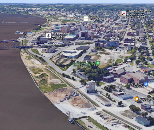
Davenport, IA: 1892 Robin Hood Flour Mill and Explosion

(Satellite, it was at the end of Federal and Tremont Streets.)

The flour mill had a major explosion on May 23, 1975. Two workers were killed instantly, and two more died in the hospital. Five others were hospitalized. [BrightHub numbers vs. Facebook comment numbers] 

Flour mill operations resumed the week after the disaster, but it took a year to rebuild the elevator. [DavenportLibrary] I have not been able to find when the facility was removed from the riverfront.

Davenport Iowa History posted
Robin Hood Flour - 1947
Pictured is the Robin Hood flour mills of the International Milling Company, 803-823 E. River Street, as seen from the Mississippi River.  In 1947, the International Milling Company also operated mills in Detroit, Buffalo, and Baldwinsville, New York.  They also had a prospective plant opening in Cleveland and on November 3rd, purchased the Capitol Elevator Company of Duluth.
In 1947, local housewives could purchase a 5 lb. bag of Robin Hood flour for 43-cents. 
Originally established in 1892 as the Riverside Milling Co., it was purchased by the Western Flour Mills Co. in July of 1904.  The mill manufactured flour and feed and was known for its Goldrim brand flour.  In 1942, the name was changed to Robin Hood Mills of the International Milling Co.
Tragically, on Friday, May 23, 1975, a spark ignited the dust inside one of the big grain silos causing a huge explosion, which left four dead, five injured and reduced much of the facility to rubble and debris.  The blast blew windows open in the Davenport Bank and Trust building a half-mile away.

Retro Quad Cities posted
May 1975 Davenport aftermath of the Robin Hood Flour silo explosion.iving Memory History: The Robin Hood Flour Mill Explosion
Posted on May 24, 2010 by SCblogger
History is full of landmark events—world, national, local— which bring people together to compare notes: 
Did you see it?  Did you hear it?What were you doing?  Were you there? 
Those in downtown Davenport experienced their own landmark event around noon on May 23, 1975, when a massive explosion on the riverfront shook the city.
Doors flew open from the percussion and windows shattered, throwing jagged spears of glass to the sidewalks.  People ran outside to find out what had happened—most thought it was an earthquake, some thought it was a bomb.  Others worried that the Rock Island Arsenal was the source of the blast.
Sirens filled the air and a helicopter flew in and stopped near the Mississippi River.  The curious ran in that direction or headed for high vantage points—the upper floors of the Blackhawk Hotel or the Kahl Building—to get a better view of East River Drive.
And what a view there was.
Half of the International Multifoods complex seemed to have lifted up and collapsed onto the other half.  The large profile of Robin Hood on one of the riverside buildings—which had given the place its local nickname, the “Robin Hood Flour Mill”—appeared to have launched itself into the Mississippi.  Pieces of reinforced concrete had been thrown at least a hundred feet in every direction.  A grain barge near the edge of the river had sunk under the debris.
But what could have caused such destruction?
Such a simple thing:  a spark had ignited the dust inside a grain silo—one of the big ones, with a capacity of 1.8 million pounds of wheat —which had exploded with devastating force.
Seven people were trapped on the remaining roofs of the complex and the firefighter’s ladders couldn’t reach two of them—one in an area that was at risk for a second explosion.  A military helicopter came to assist.   Five ambulances, plus one from Arsenal Island, took the seriously injured away to the disaster stations, where all area doctors had been told to report.  Five employees were in critical condition and were later moved to burn centers.
One body had already been found in the wreckage:  Ferrell Cleeton of Davenport. By the time the Quad-City Times came out that evening, his was the only confirmed death, though three people were still reported missing.  It was thought that one man had been blown into the river. 
By May 26, cranes were clearing the rubble and an auger was expected to soon clear the still-smoldering grain from the bottom of the silo.  Only one worker was still unaccounted for:  Leon Robinson of Milan, Illinois—the man who had been seen in a control tower on the levee barely a minute before the blast.  His fellow workers protested the machinery, wanting to hand-search the wreckage in case their friend was still alive.
But time was passing, and the next day, a barge from the U.S. Corps of Engineers carried a crane from LeClaire to help lift debris from the sunken barge.  On May 29, the bucket of the crane pulled Mr. Robinson’s body from where it had been trapped underneath the wreckage.  The Scott County medical examiner reported that he had died before he and his tower had hit the water, though this was scant consolation for his family and friends.
Total damages to the complex were estimated to be three to five million dollars.  Although a new grain elevator would take almost a year to build, flour mill operations resumed the week after the disaster, as that part of the complex had been the least damaged.   The plant was able to keep a large number of its employees occupied with cleaning and salvaging work—over 400,000 bushels of grain needed to be removed from the undamaged silos.  Soon, the only evidence of the disaster was the absence of the familiar logo, which was not replaced.
Retro Quad Cities shared

This photo taught me that the mill was upstream of Lock #15.
Davenport Iowa History posted
Robin Hood Flour Mill
As the tugboat Ann Brent pushes barges through lock and dam No. 15, Robin Hood Flour stands as a familiar backdrop along the Davenport shoreline. The Robin Hood Flour Mill was located at 803 E. River Dr. beginning in 1942. It was previously known as the Western Flour Mill, home of "Goldrim" flour, and before that the Riverside Milling Co., established in 1892. Tragically, in May 1975, a spark ignited the dust inside one of the big grain silos causing a huge explosion, which left four dead, five injured and reduced much of the facility to rubble and debris. The blast blew windows open in the Davenport Bank and Trust building a half-mile away.

 I used an old aerial photo to find that it was at the end of Federal Avenue.
1938 Aerial Photo from ILHAP

The mill employed about a 100 workers, but many of the employees were away because the explosion happened during the lunch hour. A helicopter had to rescue some of the workers that were trapped on the roof of the remaining portion of the mill. [bettgrowl

The railroad by the elevator was the Davenport Rock Island & North Western Railway (DRI), which was jointly owned by CB&Q and Milwaukee.
1953 Davenport East Quad @ 24,000


Retro Quad Cities posted
1975 Davenport Riverfront.
Christopher Smith: You can see where the remains of the flour plant are... I remember French and Hecht being down there too because of the huge stack. Our company is in the West end so we'd drive through town a lot as kids. I was one when this was taken.
Retro Quad Cities: This record is from the Upper Mississippi Valley Digital Image Archive, http://www.umvphotoarchive.org, a collaborative project of cultural heritage organizations in the Iowa-Illinois Mississippi River region.
Retro Quad Cities shared
Michael Scheel: Be nice to see a current aerial shot to compare.

Dennis DeBruler commented on Michael's comment
 https://maps.app.goo.gl/tavhiqcq8P15WCLc8