(Update: so it should have been in the other blog. It's not a big enough problem to try to fix.)
 |
| Screenshot @ -1:01 |
These are notes I am writing to help me learn our industrial history. They are my best understanding, but that does not mean they are a correct understanding.
 |
| Screenshot @ -1:01 |
 |
| TheSouthern, photo 12 of 27 The story that accompanied this photo, published in The Southern on Feb. 15, 1968, reads: "Old Ben Coal Corp. mine No. 9 at West Frankfort, the oldest operating deep shaft coal mine in Illinois, has closed down effective today, company officials announced. The last shift at No. 9 finished working at midnight Wednesday. The mine, which employes 311 men, closed because of 'the greatly changed character of present coal markets and the ever-increasing costs of underground mining in over-age properties,' according to a press release issued by Old Ben." TheSouthern Larry Joe Jenkel posted |
 |
| Dave Durham posted Old Ben Coal Mine 1920s, West Frankfort, Newberry Library, Chicago and the Midwest [I presume this is #9 instead of Old Ben #8.] |
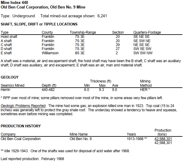 |
| west-frankfort from counties, p19 |
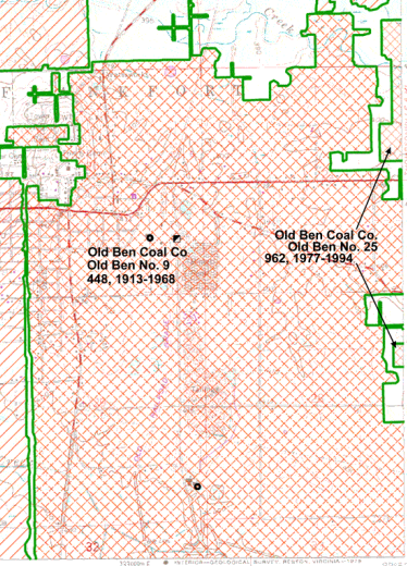 |
| west-frankfort from counties, p i, 290% |
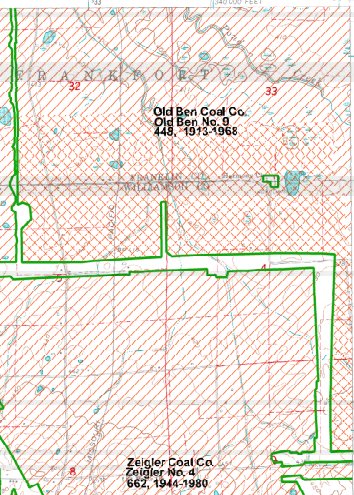 |
| johnston_city from counties, p i, 80% |
 |
| 1938 Aerial Photo from ILHAP |
 |
| Satellite |
 |
| First photo in an album of 39 photos of this railyard (source) East End of Hollidaysburg, Blair County with the Pennsylvania Railroad Car Shops around the mid-1950's. (Photo from Daniel Stephen Sheterom via https://www.facebook.com/groups/AncestralHollidaysburg/) [The long white building was the Samuel Ray Shops that replaced the steam engine facilities in 1954. It manufactured, as well as rehabilitated, freight cars.] |
 |
| Jackson-Township historical preservation posted Pennsylvania Railroad Sam Rea Shops in the town of Hollidaysburg, Blair County. Originally built by the Pennsylvania Railroad at a cost of $14 million and opened in 1956, the (then) state-of-the-art Samuel Rea Car Shops employed over 1400 people and could produce 50 new freight cars each day. (Photo from Daniel Stephen Sheterom via https://www.facebook.com/groups/AncestralHollidaysburg/) Glenn Pupino: Imagine a time when 50 new freight cars a day were needed. James Fennell shared |
 |
| Jackson-Township historical preservation posted Pennsylvania Railroad Round House in the town of Hollidaysburg, Blair County in November of 1911. The Powerhouse can be seen at the left. (Photo from Thomas C. Ayers) |
 |
| Jackson-Township historical preservation posted Pennsylvania Railroad Roundhouse in Hollidaysburg, Blair County. This was ;pcated at the East end of Sam Reigh Shops. The hill in the background is where the East Loop Rd. came out of Hollidaysburg. (Photo from Jack Eichenlaub via https://www.facebook.com/groups/Altoonahashustle/) |
 |
| Jackson-Township historical preservation posted Pennsylvania Railroad Sam Rea Shops in the town of Hollidaysburg, Blair County. Originally built by the Pennsylvania Railroad at a cost of $14 million and opened in 1956, the (then) state-of-the-art Samuel Rea Car Shops employed over 1400 people and could produce 50 new freight cars each day. (Photo from Daniel Stephen Sheterom via https://www.facebook.com/groups/AncestralHollidaysburg/) |
 |
| 1963/65 Holidaysburg and Frankstown Quads @ 24,000 |
 |
| Another photo from the photo album Interior of the Pennsylvania Railroad Samuel Rea Shops in Hollidaysburg, Blair County in May of 1957. (Photo from Thomas C. Ayres via https://www.facebook.com/groups/AncestralHollidaysburg/) Thomas C. Ayers This is a production line view of H-36 Hopper Cars taken in May of 1957. Bert Veldhuizen I had no idea fluorescent lights were around back then? Ralph Ciccone They've been around at least since the 1930's. |
 |
| Jackson-Township historical preservation posted Here is an aerial photo of the Pennsylvania Railroad's Yards in Hollidaysburg, Blair County, that was taken by Thomas Hollyman around 1953. Looking East towards Frankstown, the Westbound Classification Yard is on the left and the Eastbound Receiving Yard is on the right. The Roundhouse has been demolished and preparations are being made to construct the half-mile long Samuel Rea Shop. All that remains from the "Age of Steam" is the wooden water tower in the center of the photo. (Photo from Thomas C. Ayers) |
 |
| Curry Rail Services |
 |
| Curry Rail Services |
 |
| Curry Rail Services |
 |
| Curry Rail Services |
 |
| AJ Grigg's Abandoned Railroad Map |
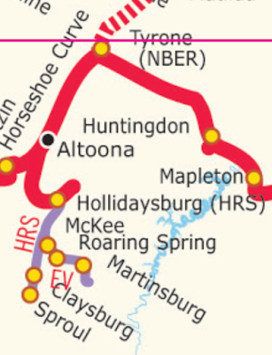 |
| NS System Map |
 |
| 3D Satellite |
 |
| Frank Lukashow posted Motorola building 9401 w grand ave franklin park il Judy Foertsch: I worked at Motorola on Augusta in the 60s and my husband worked at Motorola on Cicero in the purchasing department! One of his coworkers was George Lopez who was not a professional comedian at that time but kept the purchasing department in stiches! |
 |
| 1 |
 |
| 2 |
 |
| 3 |
 |
| 4 |
 |
| 5 |
 |
| 6 George J. Zerante When we were kids we rode our bikes through the lower level. |
 |
| Street View |
 |
| Larry Senalik posted
Strip Mine - probably east central part of the state based on the other pictures in this collection 10/24/1951
#sangamonvalleycollection
James Stine Well, it took me a bit, but we can tell you where and what’s here. This is the United Electric Coal’s Cuba No. 9 which was located near Cuba, Illinois. The machines are a BE 950-B stripping shovel in the foreground and the W-1 Koble Wheel at the back of the cut or pit. James Stine If you look in the upper right hand corner of this photo, I believe that’s another 950-B belonging to Truax Traer Coal and is their Fiatt Mine. Alan Hummel That looks like County Route #5 and the TP&W [now Keokuk Junction Railway] track at the upper end of the pit. Must have been in the late 50's. |
 |
| One of several photos in a 1958 brochure provided by Charley Smart that describes the wheel excavator. |
 |
| Roger Kujawa posted United Electric Coal Mine 9 Cuba, Illinois. Wheel excavator. John Carson Great picture. When I was a child I remember stopping and watching a Wheel and Shovel pair work outside of Cuba Il. I remember seeing equipment like these mine along Il. Rt. 95 west of Cuba, and along the Canton -Cuba blacktop. I do not know if this particular Wheel and Shovel were the ones that were moved to mine the Banner Marsh area, but somebody knows for sure, I remember them sitting silent in a field near Banner, until they were disassembled and moved to the Industry Mine which was starting up. I met the gentleman who was an Engineer with Bucyrus-Erie, who was in charge of their reconstruction, and he showed me around several times during the process and I got to see the engineering blueprints. He told me that the Wheel originally started life as a Steam Powered Bucyrus-Erie shovel. Freeman United Coal Company came up with the idea for the wheel, which was a cooperative venture between B-E and Freeman. This wheel was either the first or second one. The thing that amazed me was this Engineer (I can't remember his name), was showing me these HUGE parts and explaining how this or that was worn out and had to be replaced. He knew them by sight to be good or bad. More amazing was Bucyrus-Erie had replacement parts in stock. I was up in the Cab of the Shovel several times while it was in operation. Nice little benefit of being a Deputy Sheriff on Night Patrol. As I understand, both the Wheel and Shovel from the Industry Mine were scrapped when it closed. . JCC |
 |
| Justin Curless posted United Electric Cuba Post Card Photo - Unknown Year: This Machine is Similar to another '' Wheel Machine" set up at the Fiatt Mine in about 1962.The back of the post card says . W-4 Kolbe Wheel Excavator , in operation near Canton, illinois. Constructed at United Electric's Cuba illinois,Mine,This 2100 ton Mobile giant was developed by Frank F . Kolbe. Powered by Electricity for overburden removal in open pit pit mining, it is this Nations largest in both size Capacity. Tall as a Fifteen story building and 420 Feet long,it's maximum capacity is 4,800 cubic yards per hour. Justin Curless posted United Electric Coal Strip Mine Excavator Cuba illinois 1950 S |
 |
| Justin Curless posted Shown here is one of the Cross-Pit Bucket Wheel Excavator Machines Built By The United Electric Coal Companies(Now Freeman-United Coal Mining Company).The one illustrated was Known as The W4 Kolbe Wheel,Named. after The Company's President Frank Kolbe. It Started work at the Cuba Mine in Illinois in 1959,and Could excavate at the tremendous rate of two million Cubic yards of overburden per month. The'Cross Pit Bucket Wheel excavator had its Discharge boom fixed in the same position as the digging Boom. Kent Beckner THEY DEAD HEADED IT CROSS COUNTRY T0 BUCKHEART MINE .I BELIEVE IT WAS 1967 IT WENT TO THE SOUTH PIT WITH THE 1650 |
 |
| Justin Curless posted Kolbe Wheel-Near Cuba Roman Keating Any mines still operate in Illinois? Myron Dudenbostel Peabody's Gateway Mine at Coulterville, Carter Coal has several underground and strip mines in the area also......... Lennie Hanner I work at Prairie State Generating Company's Lively Grove underground mine, in Washington County, near Marissa. Pat Willard W-4 on it way to Buckheart mine. Bill Richter Pat i have a full page out of daily ledger showing w4 crossing route 78 |
 |
| Justin Curless shared Stine James' photo In Jan. of 1959, at the Cuba Mine of United Electric Coal, the Kolbe W-4 BWX began its work assisting the 950-B shovel which had worked the mine since 1941. The W-4 was built on the lower works of the old Marion 5600 shovel and was the largest of it's kind in it's day. The dia. of the wheel was 27 feet with ten 2.5 yd. buckets and spanned the cut some 420 feet. She could move 3500 yds./hr and weighed in at 2100 ton. I believe this machine was moved to the Industry Mine in the early 1980's and had the lower works of the first 1050-B installed on it for service there. Bruce Weirauch's posting gives photo credit to Hedrick-Blessing |
 |
| Bruce Weirauch posted 1959 Bruce Weirauch posted |
 |
| Larry Senalik posted
Pana - 9/25/1950
no additional information on the photo
#sangamonvalleycollection
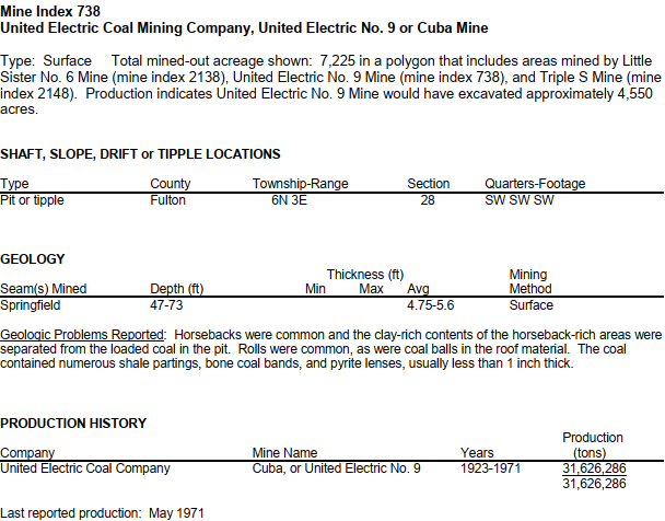
James Stine We believe this is United Electric Coal’s Cuba No.9 shops and prep plant. |
 |
| lewistown from counties, p12 |
 |
| Satellite |
 |
| Havana, IL 1949 1:62500 after searching for Cuba IL |
 |
| 1938 Aerial Photo from ILHAP |
 |
| Satellite |
 |
| Digitally Zoomed |
 |
| Burlington, IA 1958 (1976 ed.) 1:250000 after searching for Cuba IL |
 |
| Satellite |
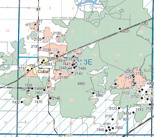 |
| Excerpt from Fulton County Mine Map |
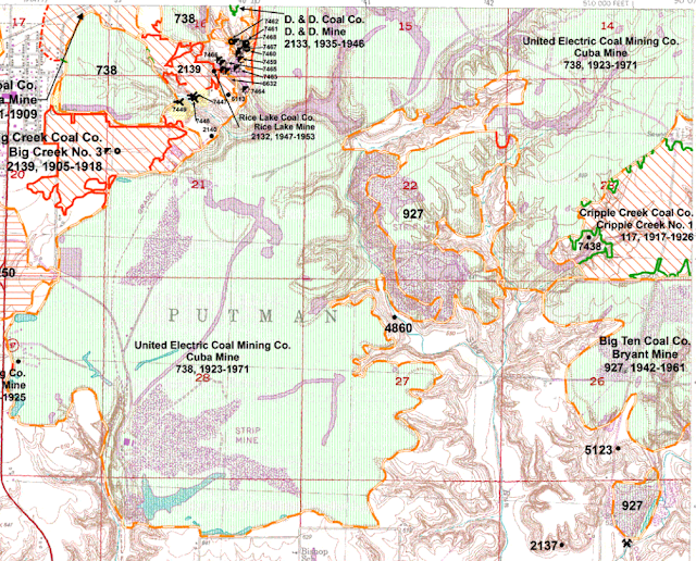 |
| lewistown from counties, p i |
 |
| Justin Curless posted, cropped and at posted resolution Shown here in this Photo is a little Story of Coal Mining. |
 |
| 1 |
 |
| 2 |
 |
| 3 |
 |
| Justin Curless posted United Electric Cuba Coal Mine Complments photo of Carlos Shaw Montey Johnson I remember this move the highway had a dip in it from the crossing. |
 |
| Bruce Weirauch posted 1965 [At Facebook resolution] |
 |
| Bruce Weirauch posted 1 of 3 Alan Hummel Bruce, I couldn't find a date on this article. Do you know when it was published? Bruce Weirauch Alan Hummel 65 |
 |
| Bruce Weirauch posted 2 of 3 |
 |
| Bruce Weirauch posted 3 of 3 |
 |
| Roger Kujawa posted EARLY CUBA ILLINOIS Real Photo Postcard Strip Mine - United Electric Coal Mine Roger Kujawa posted with the same comment James Stine: I’m glad you got that Roger Kujawa. You beat me out on this one. This was the first stripping shovel to be mounted on crawlers. It a Marion 350. It forever changed the industry. |