Thursday, September 28, 2023

Hanover, PA: Vulcan/Bethlehem Limestone Quarry

(Satellite)

Western Maryland is the railroad that served this quarry.

Remembering Bethlehem Mines posted three photos with the comment: "Hanover Quarry 2018
James Torgeson shared
The former Bethlehem Steel Hanover limestone quarry.
1

2

3

The original pits were over by PA-94. They are now full of water.
1944 Mc Sherrystown Quad @ 24,000

By 1966 they started opening up today's quarry.
1966 Mc Sherrystown Quad @ 24,000


Wednesday, September 27, 2023

Glen Lyon, PA: Coal mine and another collapse

(Satellite)

Glen Lyon, PA posted
The Glen Lyon Coal Breaker
John Selecky: The divider.......this side and the other side!!
Barbara Kielar Kline: Remember it well, too. Big deal, walking to the movies on "the other side of the breaker"
Edward Blockus: I remember the fire of this thing...had burning embers fall out of the sky into my backyard in Sheatown..I remember we had no school for a week @ Pulaski because of it.
Thomas Hill: I remember the night it burned, it was hard to stand 6 blocks away.

The mine did split the town into two pieces. The Pennsylvania Railroad served this mine.
EarthExplorer: Apr 15, 1966 @ 24,000; AR1VBLH00010142

TheMischpocheTree
Owen Michael Cafferkey II provided the link in a comment in the above Facebook post

Deborah Zaleski photo via pahomepage
"Chief Kowalski said 14 of the nearby apartments have been condemned causing roughly 20 people to be displaced. There have been no reported injuries.
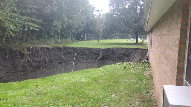
The Department of Environmental Protection says the hole is about 60 to 80 feet [34m] deep. The problem is mine subsidence in an area known for such issues through the years." The 14 apartments are in two buildings.

There is only one 1-story building in this development, so the hole is near the lower-left corner of this image.
Satellite

The mine subsidence is 750' (230m) deep. They won't let a resident go back and fetch the $100 of groceries that he just bought. And he has no more money for food. (This is low income housing.) [phl17]

wnep_sep_24_2023, Credit: Derek Sosnak
The hole had grown to 100' (30m) deep.

"This sinkhole's been a persistent problem. Officials say a sinkhole originally opened up in the same exact area back in 1981. Residents say it's a byproduct of the coal region." [wnep_sep_25_2023]

The concrete column on top of a pipe on the right side of the hole is one of the vent pipes for the mine.
Photo via TimesLeader
"Connelly said that the apartment building does not appear to have shifted, which is a good sign, but heavy rainfall is contributing to the ground being moist and unstable."

CitzensVoice
[I think that hole is worthy of a bigger excavator. Or do they backup the dump trucks to the edge of the hole?]

Underground Miners posted four photos with the comment: "It Appears the Glen Lyon No.6 shaft has subsided open!"
1

2

3

4

John Corgan commented on Photo 1
Is the location highlighted in yellow the elevator shaft location and the area circled in red the original mine entrance slope ?

Underground Miners posted four photos with the comment: "A 1930 photo of the Glen Lyon No 6 shaft that subsided today. You can see the location overlayed on a surface mine map. Also some better photos of the subsidence thanks to a friend. The debris on the roof of the building in the previous post is actually from a 60’ tree that fell, now completely swallowed by the subsidence. It is continuing to grow in diameter and depth."
Peter Stockschlaeder: Reinforces the idea/need that the mine maps should be all digitized and also build the appropriate 3D models. I know there's some projects out there already but hopefully this will get some higher priority now!
Bobby Hughes: Peter, your suggestion is currently being done and has been ongoing for over a decade or more to get any publicly available mine maps and some private collections into the PA Historic Underground Mine Map Inventory System (PHUMMIS). Our non-profit has been working with the State for a long time to scan, catalog, digitize, georeference, and mosaic the mine maps from Wilkes-Barre PA DEP BAMR Office, and the Pottsville District Mining Office, and Deep Mine Safety collection, in addition to Earth Conservancy's Maps and Girard Estates. Over the years, several other universities have been working on this type of work as well. The mine maps you can review today on the Mine Map Atlas that is served up on Penn-State's server has tens of thousands of maps, both surface and underground that EPCAMR has completed and then are approved before being uploaded to the Atlas. The 3D modeling will come. We have some examples of some 3D modeling we've completed years ago using Earthvision, GlobalMapper, and more recently ArcGIS Pro on our webpage. www.minemaps.PSU.edu
David John Briggs: In the UK we cap the shafts like this at rock head. Imagine a champagne cork. The concrete plug below this cap goes down many yards. The shafts back filled with clean limestone from pit bottom upwards and when the filling gets to any water aquifer, the shaft men will have removed the brick shaft lining and that area will be filled with clay to many yards thickness, thus sealing the aquifer from the mine water in the shaft over time. The limestone infill continued to the surface. A vent placed in the cap to vent any methane collecting under the cap ,as over time the limestone in the shaft will settle ,thus leaving a void under the cap.
This type of cap is built to last a minimum of 400 years….. after that 🧐🧐🧐🧐🧐
1

2

3

4

Sue McCormack commented on the above post
Year not known

Underground Miners posted four photos with the comment: "Continuing the hot topic of the Glen Lyon No.6 Shaft subsidence, special thanks to JPVideos for some drone shots! Thanks Jason!"
1

2

3

4


The above 1981 date for the previous collapse appears to be wrong. This article is dated Dec 31, 1982.
newspapers
[Rather than just put a concrete cap over a 750' shaft, they should have first filled up the shaft. The shaft is now getting some fill. Unfortunately, it is from someone's backyard.]

Underground Miners posted nine photos with the comment: "One more post on the Glen Lyon No.6 Shaft subsidence. This batch of photos is from the first time it subsided open in the early 1980s while the apartments were being constructed. The actual elevator shaft was visible that time at the bottom of the funneling ground."
1

2

3

4

5

6

7

8

9


Serena, IL: CB&Q Depot and Old Grain Elevator

Depot: (Satellite, just southwest of the crossing and between 3806th Road and the tracks.)
Elevator: (Satellite, about where the guts of today's elevator stands.)

Jeff Mathre posted
Serena,Il
Eric Skretteberg: Was it where the grain silos are now, east side f ttracko

Dennis DeBruler commented on Eric's comment
It was west of the tracks. There used to be a small yard in town, and the grain bins are built on what was the yard tracks. 1937-47 aerial photo. (Until this month, Illinois gave the exact year for a photo. Why does software change for the worse?) https://prairie-research.maps.arcgis.com/.../index.html...

Jeff Mathre posted with the comment: "Laverne Hudson collection, he worked during the 50-60's."
Robert Carter: Love the flags! Of course it's an extra.
Mike Bartels: These had to run as a "train" because without hi-rail gear they had no way to get off the track by themselves. There is a mechanism underneath to change direction.


Tuesday, September 26, 2023

West Pittsburg, PA: 1900-95 B&O Union Valley (UN) Tower and 1907 P&LE Depot

Tower, Original: (Satellite, half way between Union Valley Road and the McKee Run Creek)
Tower, Preserved: (Satellite)
Depot: (Satellite)

See also my 2024 notes. See"New Castle, PA: Preserved B&O (UN) Junction Tower" for the current location of the tower.

The tower was at the south (timecard east) end of the CSX/B&O New Castle Railyard.

It was built between 1890-1900, and it had 32 levers. [angelfire]

Robby Beck posted
EB departing New Castle, Pa
[The tower operator is holding a hoop with train orders. I wonder if that conductor was supposed to grab his orders instead of waving to the railfan. If someone from a window had already taken the orders, I don't think the operator would still be holding the hoop near the caboose.]

Note the yellow panel hanging out between two windows. It could be replaced by a red panel. There were also yellow and red lights for nighttime operation. Yellow meant "19" orders and red meant "31" orders. [TrainOrders]
"Yellow to signal the train crew that orders were being hooped up to them and Red to signal the train had to stop, collect, and read their orders before proceeding." [angelfire]


Darren Reynolds posted seven photos with the comment: "B&Os "UN" Tower   West Pittsburgh, Pa."
1

2
[I always appreciate a view of signalling pipelines. These pipelines were replaced by powered switches that were controlled by the armstrong levers. The interlocking plant still controlled the levers even after the pipelines were removed.]

3

4

5

6

EarthExplorer: Apr 20, 1969 @ 24,000; AR1VCFB00020036
 
Darren Reynolds posted eight photos. Let me know in the comments which one is the new one.
UN also controlled movements of trains to and from the junction with the Pittsburgh and Lake Erie Railroad on which the B&O had gained trackage rights between McKeesport, PA and New Castle, PA in 1934 to run P&LE's level river route along the Monongahela and Ohio Rivers avoiding their own hilly and winding P&W route north of Pittsburgh, PA. The Pittsburgh and Western was a former narrow gauge line bought up by the B&O and converted to standard gauge during the B&O's push westward to Chicago.
The P&W and P&LE Routes converged near West Pittsburg allowing for an interchange of traffic between the P&LE and B&O in New Castle Yard. CSX would eventually take over the P&LE on September 12, 1992 giving dispatchers two routes through the Pittsburgh area.
Because UN Tower was built in a strategic location B&O, Chessie System, and CSX management always saw to it that only the most experienced tower operators were assigned to work UN. Mr. Don Piccirillo was the last operator to work UN Tower for CSX and he recalls that four operators worked UN around the clock with a fifth man working the extra board.
Mr. Piccirillo states that "UN was a complicated place to work". "All trains got orders at UN and that kept the operator on his toes". An operator would have to contact three different dispatchers (New Castle Sub, P&W, and P&LE) just to move a train through the interlocking. Likewise the P&LE dispatcher would have to call the UN operator to move his trains into New Castle Yard.
Movement past UN Tower required three sets of train orders depending on how the train was routed. Generally more orders were needed to go East to the P&W or P&LE than West toward Ohio. "When hooping orders, you could catch an Eastbound from the first landing on the stairs and the caboose three steps up from the ground" Said Mr. Piccirillo.
P&LE is on the left, and B&O is on the right. Today, CSX has the P&LE route and Buffalo & Pittsburgh has the B&O route.
1958 New Castle South Quad @ 24,000

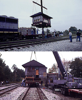
"This was one of the last 'armstrong' towers in operation on the former B&O lines. After it closed, it was moved to nearby Mahoningtown where is has been cosmetically restored for display." [TrainOrders]

Steve Raith photo via angelfire
 
Todd Dillon Flickr, Jun 2012

I saw a comment that suggested it needs to be preserved again. Other comments indicated that the interlocking plant was probably not preserved.
Street View, Aug 2023


HawkinsRails
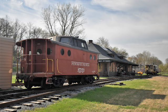
It was built in 1907. "Today the station is the official home of the Beaver-Lawrence Railway Historical Society."

They have been adding track to their exhibit.
Brian Manville, Apr 2023

blrhsinc

(For future reference: New Castle depots and freight houses.)