(Update: another salty docked at this elevator)
https://www.google.com/.../data=!3m1!1e3!4m5!3m4...
https://industrialscenery.blogspot.com/.../cofcocontinent...
Dennis DeBruler Since they are loading barges in Jeff's photos, they evidently export via the Illinois Waterway and the Gulf of Mexico rather than the St. Lawrence Seaway.
Dennis DeBruler They sometimes use salties.
 |
| Shawn Conrad, Oct 2016, cropped [The four ship cranes that are turned out of the way indicate that this is a general purpose "salty." Not a specialized bulk carrier.] |
 |
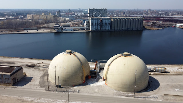
| Jeff Wojciechowski posted COFCO Intl grain elevator. Port of Milwaukee, WI For clarification the domes in the foreground are for salt storage 4/4/2021 |
Jeff Wojciechowski posted three photos with the comment: "Port of Milwaukee, WI Soybeans being transloaded to a barge 5/22/2019"
Dennis DeBruler Like the Nidera/Continental B House in Chicago, this elevator is now owned by COFCO. I understand it is a Chinese company.https://www.google.com/.../data=!3m1!1e3!4m5!3m4...
https://industrialscenery.blogspot.com/.../cofcocontinent...
Dennis DeBruler Since they are loading barges in Jeff's photos, they evidently export via the Illinois Waterway and the Gulf of Mexico rather than the St. Lawrence Seaway.
Dennis DeBruler They sometimes use salties.
 |
| Ray McCollough posted |
 |
| Ray McCollough posted |
There are some more views of this elevator in this photo collection.
 |
| safe_image for 12 vintage photos of Milwaukee's Harbor District at work Milwaukee at work in what is now being redeveloped and transformed as the Harbor District. This was a major Lake Michigan waterfront industrial area. |
.jpg) |
| Association for Great Lakes Maritime History posted An image of the canal-sized freighter William Schupp at the grain elevator on the Kinnickinnic River in Milwaukee, Wis. on Nov. 23, 1934 (Image Source: Milwaukee Public Library Digital Collections). The ship appears to be loading grain bound for Poland. The original caption indicated that it was “discharging (a) cargo of Polish grain.” However, ship unloading equipment was not installed at the elevator until 1940 (see below). [Ship history has been deleted.] Additional Historical Information – Kinnnickinnic Elevator In 1916, the Chicago & Northwestern Railway built a grain elevator on the banks of the Kinnickinnic River in Milwaukee, Wis. The structure was located near the point where the river empties into the Milwaukee River shortly before that river flows into Lake Michigan. Soon known as the Kinnickinnic Elevator, it consisted of a workhouse and 72 circular concrete storage bins each 15 feet in diameter and 90 feet high. Total storage capacity was 1.5 million bushels. Grain would arrive by rail in 40-foot box cars, be transferred to storage bins and then transferred to ships bound for ports in the Great Lakes region and beyond. Updike Grain of Omaha, Neb. operated the facility until 1921 when Donahue-Stratton, a Milwaukee-based grain dealer, acquired Updike’s lease. An annex was completed in 1930 just north of the original structure. It included 48 circular concrete bins with each bin 25 feet in diameter and 90 feet high. This increased total storage capacity at the site to 3.5 million bushels. Donahue-Stratton would become Stratton Grain in 1935. In 1938, company officials declared the Kinnickinnic Elevator to be one of the fastest grain handling grain facilities in the U.S. It could transfer grain into ships docked alongside at a rate of up to 700,000 bushels per eight-hour day. The next major improvement was the installation of a marine leg in 1940. The device extracted grain from vessels and could unload 15,000 bushels per hour. The elevator was now able to handle both incoming and outgoing shipments of grain by water. In its first test, the system transferred 250,000 bushels of wheat from a ship originating at Duluth, Minn. to rail cars bound for Chicago, Ill. At the time, lake-rail shipping costs through Milwaukee were competitive with those of an all-water route to Chicago. In 1960, New York-based Continental Grain replaced Stratton Grain as the operator of the elevator. By then more grain was arriving by truck, so Continental invested in a high speed “truck dump” system that could empty ten trucks per hour. In 1979, a second dump was added that allowed the elevator to handle up to 30 trucks per hour. The Chicago & North Western Railway offered to sell the Kinnickinnic elevator to the City of Milwaukee for one dollar in 1970. At the time, it was the only elevator in the port accessible to oceangoing vessels and had handled 217,000 tons of grain in 1969. City officials declined the offer and Continental Grain ultimately acquired the operation. In 1999, Minneapolis-based Cargill acquired Continental’s commodity marketing business. Concerned with market concentration, the U.S. Justice Department approved the deal only after Cargill agreed not to buy several facilities, including Continental’s Milwaukee elevator. In late 1999, the structure was sold to Chicago & Illinois River Marketing, a subsidiary of Dutch grain trader Nidera. The elevator received its last inbound cargo by ship in 2014. In 2017, Nidera was acquired by the China Oil and Foodstuffs Corp. (COFCO). Several years later, COFCO announced that it would be closing the Kinnickinnic elevator and sold the site to Ozinga, an Illinois-based concrete supplier. On Jan. 23, 2023, the last of the grain stored in the elevator was removed and loaded into the bulk freighter John J. Boland for delivery to Chicago. Information Source: Fred Bultman: She is loading grain for Montreal most likely, where it would then be transshipped to Poland. |
 |
| OnMilwaukee Kinnickinnic elevator circa 1925. (PHOTO: Milwaukee Public Library) "The century-old Kinnickinnic elevator could not compete with the new Agricultural Export Facility, financed primarily by taxpayer dollars, scheduled to open later this year....(NOTE: From 1958 to 1989, Cargill owned and operated Elevator E built by the Milwaukee Road along the South Menomonee ship canal. Because this channel was narrow and shallow, larger oceangoing vessels could not access the Cargill elevator.)....The $40 million facility is being funded with money from the U.S. Department of Transportation's Port Infrastructure Development Program ($15.89 million), Wisconsin Department of Transportations Harbor Assistance Program ($9.53 million across three years), Port Milwaukee ($5.7 million) and the DeLong Co. ($8.88 million)....The facility is expected to be completed by late April and opened in May." [This article includes a photo of a freighter unloading barley from Denmark into trucks in Oct 2014. I guess there are still some breweries left in Milwaukee. Those trucks hauled the barley 800' to this elevator. Ozinga bought the elevator for $4m. Can they store cement in the existing silos? Or are they willing to tear it down to get dock space?] |
Sep 14, 2023:
 |
| Jeremy Whitman posted A calm morning in Milwaukee’s inner harbor for a fist time visitor the Onego Bayou. This is the second ship ever to load at the new Delong facility. Steve Miller: What are they loading. Jeremy Whitman: Steve Miller distillers grain. |


%20Abandoned%20Rails%20_%20Last%20weekend,%20I%20braved%20the%20frigid%20cold%20and%20explored%20more%20.png)


